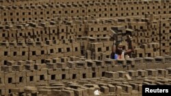
Researchers in England are hoping to help root out modern-day slavery in northern India by using detailed satellite imagery to locate brick kilns — sites that are notorious for using millions of slaves, including children.
A team of geospatial experts at the University of Nottingham use Google Maps and dozens of volunteers to identify potential sites of exploitation and report them to authorities.
"The key thing at the moment is to get those statistics right and to get the locations of the brick kilns sorted," said Doreen Boyd, a co-researcher on the "Slavery from Space" project.
"There are certainly activists on the ground that will help us in terms of getting the statistics and the locations of these brick kilns to [government] officials."
Anti-slavery activists said the project could be useful in identifying remote kilns or mines that would otherwise escape public or official scrutiny.
"But there are other, more pressing challenges like tackling problematic practices, including withheld wages, lack of transparent accounting ... no enforcement of existing labor laws," said Jakub Sobik, spokesman at Anti-Slavery, a London-based nongovernmental organization.
Millions of people in India are believed to be living in slavery. Despite a 1976 ban on bonded labor, the practice remains widespread at brick kilns, rice mills and brothels, among others.
The majority of victims belong to low-income families or marginalized castes like the Dalits or "untouchables."
Nearly 70 percent of brick kiln workers in South Asia are estimated to be working in bonded and forced labor, according to a 2016 report by the International Labor Organization. About a fifth of those are underage.
The project relies on crowdsourcing, a process where volunteers sift through thousands of satellite images to identify possible locations of kilns. Each image is shown to multiple volunteers, who mark kilns independently.
The team is currently focused on an area of 2,600 square kilometers in the desert state of Rajasthan — teeming with brick-making sites — and plans to scale up the project in the coming years.
Researchers are now in talks with satellite companies to get access to more detailed images, rather than having to rely on publicly available Google Maps.
The project is one of several anti-slavery initiatives run by the university, which include research on slave labor-free supply chains and human trafficking.