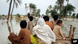
The headlines over the past few months have told of over a thousand killed in floods in Pakistan; hundreds have lost their lives and livelihoods elsewhere in South and Southeast Asia.
The question being asked by many is why this is happening.
Gerald Meehl is a senior scientist at the National Center for Atmospheric Research in the US city of Boulder, Colorado.
Why has Asian weather been so severe?
What’s been happening since spring of this year is that the “El Nino” that we had last year when the temperatures in the equatorial Eastern Pacific were somewhat above normal has transitioned to a “La Nina” when the sea temperatures were somewhat below normal.
A “La Nina” year started in the spring and then carried on through the summer, and we’re still in it now and it will probably last until spring of 2011. What happens during a “La Nina,” and this has been established by looking at a lot of “La Niña’s” going back at least 150 years, is that we tend to expect a stronger than normal South Asian monsoon. In other words, you expect to see heavy rainfall over South Asia during summer monsoon season extending into fall season. And so that is kind of what we saw this year. We saw some severe flooding events in Pakistan and in other areas of South Asia. That is something we have seen in the past during past “La Niña’s” so it wasn’t a big surprise that it happened this year in the present “La Nina.”
Does global warming play a part in this?
The global warming part of this is that the climate has been warming up and we know from how the physical system works that warmer air can hold more moisture. So as the planet is warming up, the ocean temperatures are warming up with it and the warmer ocean is evaporating more moisture. That additional moisture is going into the air; the warmer air can hold that moisture. When it's carried into a region where there is precipitation occurring, where there is storminess, you tend to see more intense precipitation. This trend of increasing precipitation intensity has been observed to occur in a lot of areas of the planet, especially over the last 30 or 40 years. So the fact that we are getting heavier than normal rainfall in this South Asia monsoon is something that you would expect to see, but the reason it’s been record breaking flooding, record breaking heavy rainfall is more consistent with the fact that we’ve had this background change in the climate.
How do you forecast the future as far as this is concerned?
The only way we really have of forecasting what’s going to happen in the future is with climate models that we run on super computers. These climate models tend to indicate that these extremes in precipitation would tend to get more extreme as the climate continues to warm because the air will hold more and more moisture as it gets warmer. That would basically continue the trends we have already seen. So physically it’s a fairly simple thing to understand and it’s a pretty basic thing that the models are able to pick up on. The models tend to continue that trend of increasing precipitation intensity on into the future.