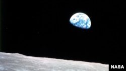
On December 24, 1968, as the astronauts of Apollo 8 orbited the Moon, they caught an amazing view of the Earth rising over the lunar horizon. They were the first humans to see it.
The view came as a surprise, so the astronauts scrambled to the get the right film in the camera to preserve the moment forever.
Too late to get the image in color from one window, astronaut William Andrews, with an assist from James Lovell, got the shot as their spacecraft turned, offering another specatcular view.
The photo, Earthrise, became one of the iconic images of the 20th century.
Now, NASA has created a video re-enacting the event.
"The Earthrise visualization that we released for Earth Day last year really only scratched the surface," said Ernie Wright, project lead with the Scientific Visualization Studio at NASA's Goddard Space Flight Center in Greenbelt, Maryland. "The new visualization tells us not only what time the photos were taken, but also exactly which way the spacecraft was pointing and therefore which window each photo was taken from. This will also be the first time we've released a video that's synchronized with the onboard audio recording of the astronauts."
To help in the recreation, NASA used data from the Lunar Reconnaissance Orbiter (LRO).
"Matching Apollo photography to the lunar terrain required an accuracy and completeness that I think only LRO's data could provide," said Wright. "I worked at a level of detail that required 100-meter resolution with perfect registration. You gain a new appreciation for the care of the LRO scientists who create this data when you get your virtual camera set up and the overlaid Apollo photography just snaps into place.
"The key to the new work is a set of vertical stereo photographs taken by Apollo 8," adds Wright. "A camera was mounted in the rendezvous window that pointed straight down onto the lunar surface. It took a picture every 20 seconds. When the spacecraft rotated, so did the images. By registering each photo to a model of the terrain from LRO data, we can nail down the timing of the spacecraft's rotation."
Wright went to great lengths to make the visualization as accurate as possible. He used the Apollo 8 flight plan, the onboard voice recording, data on the optical properties and mounting of the Hasselblad cameras, the dimensions and angles of the Command Module windows, a global map of Earth's cloud patterns from the Environmental Science Services Administration 7 satellite on the day the Earthrise photo was taken, and the position and orientation of the moon, the Earth, the sun, and the spacecraft.
Here's the video: