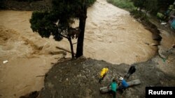
Tropical Storm Nate roared toward Mexico's Yucatan Peninsula Friday after drenching Central America in rain that was blamed for at least 22 deaths, and forecasters said it could reach the U.S. Gulf Coast as a hurricane over the weekend.
Louisiana officials declared a state of emergency and ordered some people to evacuate coastal areas and barrier islands ahead of its expected landfall early Sunday, and evacuations began at some offshore oil platforms in the Gulf.
The U.S. National Hurricane Center said Nate could cause dangerous flooding by dumping as much as 6 to 10 inches (18 to 25 centimeters) of rain as it moved over Honduras, with higher accumulations in a few places.
It had maximum sustained winds of 45 mph (75 kph) by Friday morning and was likely to strengthen over the northwestern Caribbean Sea on Friday before a possible strike on the Cancun region at the tip of Mexico's Yucatan Peninsula at near-hurricane strength. It could hit the U.S. Gulf coast near New Orleans.
In Nicaragua, Nate's arrival followed two weeks of near-constant rain that had left the ground saturated and rivers swollen. Authorities placed the whole country on alert and warned of flooding and landslides.
Nicaragua's vice president and spokeswoman, Rosario Murillo, said that at least 15 people had died in that country due to the storm. She didn't give details on all the deaths, but said two women and a man who worked for the Health Ministry were swept away by a flooded canal in the central municipality of Juigalpa.
Costa Rica's Judicial Investigation Organism blamed seven deaths in that country on the storm and said 15 people were missing. Flooding drove 5,000 residents into emergency shelters.
The forecast track showed that Nate could brush across the tip of Mexico's Yucatan Peninsula as a tropical storm late Friday night.
In Louisiana, Gov. John Bel Edwards declared a state of emergency and mobilized 1,300 National Guard troops, with 15 headed to New Orleans to monitor the fragile pumping system there.
With forecasts projecting landfall in southeast Louisiana as a Category 1 hurricane, Edwards urged residents to ready for rainfall, storm surge and severe winds — and to be where they intend to hunker down by "dark on Saturday."
Louisiana's governor says Nate is forecast to move quickly, rather than stall and drop tremendous amounts of rain on the state. State officials hope that means New Orleans won't run into problems with its pumps being able to handle the water.
Edwards warned, however, against underestimating the storm.
Officials ordered the evacuation of part of coastal St. Bernard Parish east of New Orleans ahead of the storm. Earlier Thursday, a voluntary evacuation was called in the barrier island town of Grand Isle south of New Orleans.
New Orleans officials outlined steps to bolster the city's pump and drainage system. Weaknesses in that system were revealed during summer flash floods.
The Bureau of Safety and Environmental Enforcement's New Orleans office said in a news release that as of midday Thursday, six production platforms, out of the 737 manned platforms in the Gulf, had been evacuated. No drilling rigs were evacuated, but one moveable rig was taken out of the storm's path.
The agency estimated less than 15 percent of the current oil production in the Gulf of Mexico has been shut-in, which equates to 254,607 barrels of oil per day.
Early Friday, the storm was centered about 230 miles (370 kilometers) south-southeast of Cozumel, Mexico, and was moving north-northwest at 14 mph (22 kph).
